
GIC staff and AIT Marine Plastics Abatement Program students worked together using geospatial technology to estimate waste volume at a nearby dumpsite in Pathum Thani, Thailand on April 01, 2021.
The collaboration supported the thesis of an AIT-MPA student who is working under the supervision of thesis committee member Dr. Kavinda Gunasekara, GIC Associate Director.
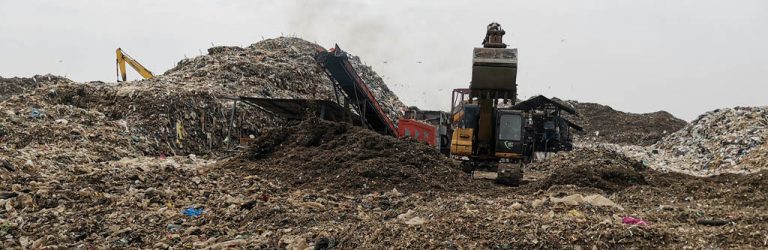
GIC elected to use aerial photogrammetry to collect images of the dumpsite combined with computer vision techniques to digitally reconstruct the dump piles within a known coordinate system. The approach was appropriate with consideration given to the safety of the field team. Other conventional survey methods of volume estimation like on-pile measurements were avoided given the nature of the dumpsite environment.
A multirotor unmanned aerial vehicle (UAV) was selected to capture high resolution imagery of the dumpsite. The area of interest at the dumpsite was a waste collection/sorting area approximately 3 ha in size, small enough to complete an aerial survey within half an hour. The multirotor configuration made it convenient to launch and land the UAV from the basecamp located across the road from the dumpsite.
Being that achieving accurate measurements of dumpsite volume was a priority for this project, it was imperative to take steps reduce geometric error in the UAV deliverables. The team opted to use phototargets as photogrammetric control which were strategically placed around the area of interest. Other phototargets were reserved as check points to understand the accuracy of the UAV deliverables. Positions of all phototargets were determined with a real-time kinematic survey using a low-cost GNSS receiver assembled by the GIC GNSS team. The receiver is capable of making centimeter-level measurements at a fraction of the cost of commercially available units.
Phototarget placement was especially challenging at the dumpsite. Although the team used reconnaissance data from a previous visit to plan the phototarget layout, changes had to be made on the fly as the dumpsite is a dynamic environment. Placement in the waste collection area became restricted due to changes in pile layout, limiting the possibility of any phototargets appearing at the center of the area of interest. Therefore, phototarget placement was limited to the periphery.
Following data collection, a commercial photogrammetry software was used to process the UAV images. The process is highly automated apart from manually selecting the centers of phototargets for control/check points. Care was put into cleaning up the dense point cloud as errant points arose from poor reconstruction in problem areas. Furthermore, vehicles and waste sorting stations were removed from the dense point cloud so that they would not affect the final volume estimation.
The dumpsite proved to be a challenging environment but the techniques and equipment employed were sufficient to achieve a volume estimation for the area of interest.