Geospatial technology provides accurate and detailed information for the agriculture industry, from crop monitoring to yield estimation to land use planning. It enables farmers and policymakers to make informed decisions based on precise data and insights, leading to increased productivity and sustainability in the industry. By utilizing satellite imagery, remote sensing, and GIS, farmers can make informed decisions about crop selection and management practices, ultimately leading to increased productivity and long-term sustainability.
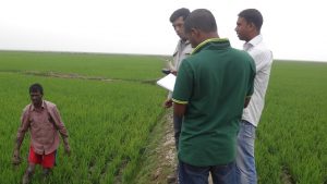
Our team uses geospatial tools and techniques to provide farmers, policymakers, and other stakeholders with the information they need to make informed decisions about agricultural practices. In practice, we are utilizing the combination of field and remote data such as satellite or UAV.
At the Geoinformatics Center at AIT, we are committed to helping farmers and other stakeholders in the agricultural sector use geospatial technology and remote sensing to improve their practices. Our agriculture expertise is based on years of research and practical experience, and we use the latest tools and techniques to provide our clients with accurate and actionable insights. Our expertise is focused on forestry, crop mapping, land suitability assessment, and crop management.