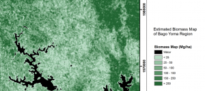
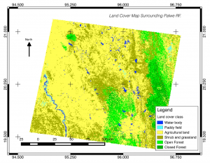
The Geoinformatics Center (GIC) at AIT has extensive expertise in using geospatial technology to monitor and protect the environment. With advanced tools for mapping, monitoring, modelling, and analyzing data; we provide critical insights and information to understand the Earth’s resources and ecosystems. Our environmental expertise ranges from managing land to water resources, supporting sustainable development, mitigating the effects of climate change, and protecting natural resources for future generations.
The application of geospatial technology has been utilized extensively on the board scale, from small-scale monitoring to regional mapping for geospatial information development. We used different methods of mapping for different kinds of issues, such as supporting the decision-making process in climate resilience, mapping the detection of land use change for development, modelling the leakage of emerging plastic waste in the river using GIS mapping techniques and CCTV, and any other works related to the climate change decision-making support.
Our leading portfolio focuses on different topics for decision-making support: waste management, climate change, urban and land use, and ecological restoration. Our expertise is also compiled with user-friendly digital tools, which can improve the data collection in real time.