
GIC responded to the extensive late wet season flooding that inundated much of central Thailand by investigating flood extent in neighboring Ayutthaya province. GIC received Synthetic Aperture RADAR (SAR) data from Sentinel Asia Program partners covering Ayuthaya, Thailand in response to the flooding that began in late September 2021. The disaster response team at GIC performed image analysis on multi-temporal satellite imagery to determine the flooded areas throughout the province.
To validate the flood map, GIC mobilized a field team to access the interpreted flooded areas to collect reference data in Ayutthaya province. The field team used innovative tools to collect the reference data including customizable mobile applications and unmanned aerial vehicles (UAVs). First, a configurable Google application provided navigation to selected flood zones throughout the province. Next, a customized data collection application was used to gather vital field information including flood condition and geospatial coordinates among others, which would later be introduced into a GIS environment for further analysis. The team also recorded aerial video and images of flooded areas using a lightweight UAV. One benefit to this bird’s eye view was in exploring the extent of the flooding, making it possible to gain a grander scope of the surrounding areas beyond what is possible at the roadside.
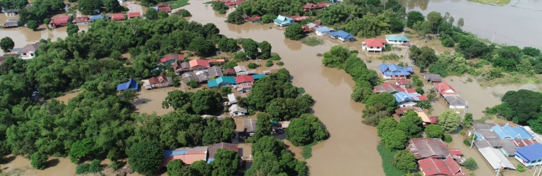
During the day, the team was able to catch up with residents of Ta Din Daeng sub-district, Phak Hai District, Ayuthaya, where relief efforts were underway. A small fleet of motor boats was on hand delivering essential supplies to residents in the nearby flooded villages. UAV made it possible
to survey the extensive flooding surrounding the Tha Din Daeng Temple Complex located just down the road from the relief boat staging area.
Sentinel Asia is a collective managed by the Asia-Pacific Regional Space Agency Forum (APRSAF) to aid in disaster management with space technology. GIC serves as the
Principal Data Analysis Node for Sentinel Asia, playing a vital role in the coordination of satellite data analysis, generation of value added mapping products, and dissemination of the results through the Sentinel Asia system.
GIC’s reference data for the late 2021 wet season flooding in Ayutthaya province can be accessed through GIC’s mapping portal.