Overview
The Geoinformatics Center has been an active technical partner in Sentinel Asia disaster activations since 2008. Sentinel Asia (SA) is a voluntary initiative that brings together space and disaster management agencies to utilize Remote Sensing (RS) and Geographic Information Systems (GIS) for disaster management across the Asia-Pacific region.
As a Principal Data Analysis Node (P-DAN) of Sentinel Asia, GIC-AIT produces Value-Added Products (VAPs) as quickly and efficiently as possible to assist end-users in disaster response and recovery. VAPs are disaster maps generated using GIS data and satellite imagery from sources such as ALOS-2, Sentinel-2, and others.
Between October and November 2025, GIC produced eight VAPs for different disaster events. Some of those disaster activations include: Flooding caused by Typhoon FUNG-WONG in the Philippines, a Glacier convergence in Safedob, Tajikobat District, Tajikistan, Flooding in Thai Nguyen Province, Vietnam, and Heavy rain-induced flooding in Nepal. In total, GIC has completed 46 disaster activations for various types of disasters around the world as of November 2025.
Disaster Activations
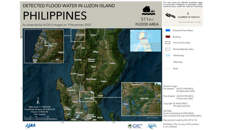
1. Flood Due to Typhoon FUNG-WONG in the Philippines
Typhoon Uwan (Fung-wong), the Philippines’ 21st tropical cyclone of 2025, brought torrential rainfall and destructive winds to Luzon, reaching a peak diameter of more than 1,800 kilometers. On November 8, 2025, the typhoon triggered widespread flooding across the island, submerging approximately 511 square kilometers and resulting in eight fatalities. GIC produced a Value-Added Product (VAP) for the flooding in the Philippines using pre- and post-disaster imagery from the Advanced Land Observing Satellite-2 (ALOS-2). The pre-disaster images were acquired on 28 September 2025, and the post-disaster images on 9 November 2025.
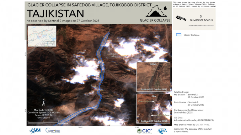
2. Convergence of Glacier in Safedob, Tajikobat district in Tajikistan
The Ismoil Somoni Glacier is one of the largest glacial formations in Tajikistan’s highlands. On October 25, 2025, a natural disaster described as a “convergence of glacier” occurred near the village of Safedob in the Tajikobat District of Tajikistan. The event involved the massive collapse of a large section of the Ismoil Somoni Glacier, located on the nation’s highest peak. The detached ice mass is estimated to have measured approximately 2 kilometers in length, 25 meters in height, and 150–200 meters in width. In response to this, GIC produced one Value-Added Product (VAP) for this glacier disaster using Sentinel-2 satellite imagery, comparing pre-disaster (17 October 2025) and post-disaster (27 October 2025) conditions.
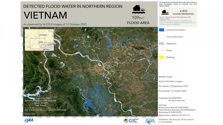
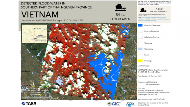
3. Flood in Thai Nguyen Province, Vietnam
Typhoon Matmo brought heavy rainfall across the Northern Region and parts of the North Central Coast, especially Thanh Hóa in Vietnam, causing widespread urban flooding on the night of October 6–7, 2025. Thái Nguyên Province was hit hardest: the Cầu River exceeded its historical peak, submerging much of Thái Nguyên City under water depths of up to 2 meters. In response, GIC generated two Value-Added Product (VAP) for the flooding in Thái Nguyên Province using Advanced Land Observing Satellite-2 (ALOS-2) imagery. Pre-disaster data from 23 September 2018 and post-disaster imagery from 12 October 2025 were analyzed. Initial assessments indicate that approximately 109 square kilometers of land were inundated, affecting around 4,800 houses in the impacted region.
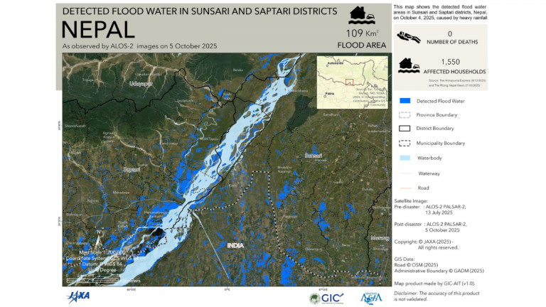
4. Heavy Rains Flood in Nepal
On 4 October 2025, heavy rainfall was recorded across 14 districts of Nepal, with several areas receiving more than 50 millimeters of precipitation. Parts of Sunsari and Saptari districts experienced the highest rainfall, ranging from 120 to 150 millimeters, which triggered flooding in the Koshi river and landslides in multiple locations. The rainfall was attributed to moisture-laden winds originating from the Bay of Bengal in India.
In response, GIC generated a Value-Added Product (VAP) for heavy rains in Sunsari and Saptari districts of Nepal using Advanced Land Observing Satellite-2 (ALOS-2) imagery. Pre-disaster data from 13 July 2025 and post-disaster imagery from 15 October 2025 were analyzed. Initial assessments indicate that approximately 109 square kilometers were flooded, affecting around 1550 houses in the impacted region.