Use of Remote Sensing and GIS in Paddy Area Mapping in Nueva Ecija
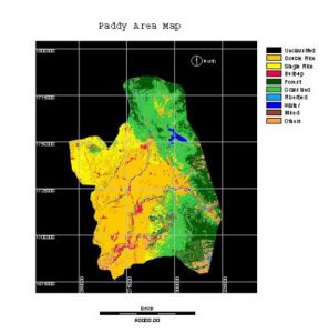
Use of Remote Sensing and GIS in Paddy Area Mapping in Nueva Ecija Year: 2004-2005Country: PhilippinesLocation within country: Nueva Ecija province The project aimed at identifying and mapping rice grown areas using a combination of remote sensing and GIS Read More