
Die Welt der E-Zigaretten: Ein Blick auf den vape elf bar
Die Welt der E-Zigaretten: Ein Blick auf den vape elf bar Einführung in die E-Zigaretten Die E-Zigarette hat in den letzten Jahren an Popularität gewonnen und ist zu einer bevorzugten Alternative für viele Raucher geworden. Sie bieten eine Vielzahl Read More

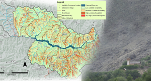
Flood Hazard Map for Effective Flood Management in the Mekong Delta
Area : Mekong delta, VietnamClient : JAXAStart Year : Apr 2012End Year : Mar 2013Partners : – Integration of Remote Sensing Data with a Numerical Model to Read More
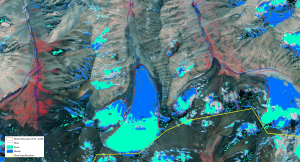
Assessment of the Current State of Glaciers in Uzbekistan
Area : UzbekistanClient : JAXAStart Year : Apr 2012End Year : Mar 2013Partners : – Assessment of the Current State of Glaciers in Uzbekistan The objectives of Read More
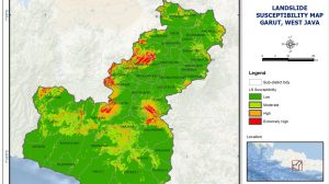
Landslide Susceptibility Mapping in Basha Diamer Dam Area Using Remote Sensing and Modelling Techniques
Area : Diamer, Gilgit-Baltistan ProvinceClient : JAXAStart Year : Apr 2012End Year : Mar 2013Partners : – Landslide Susceptibility Mapping in Basha Diamer Dam Area Using Remote Read More