
Area : Diamer, Gilgit-Baltistan Province
Client : JAXA
Start Year : Apr 2012
End Year : Mar 2013
Partners : –


Landslide Susceptibility Mapping in Basha Diamer Dam Area Using Remote Sensing and Modelling Techniques
The objectives of this project were: 1) To develop a land use/landcover map from ALOS/AVNIR-2 satellite images using Object Based Image Analysis (OBIA) technique, and 2) To delineate the landslide potential area using maximum entropy and weighted logistic regression approaches.
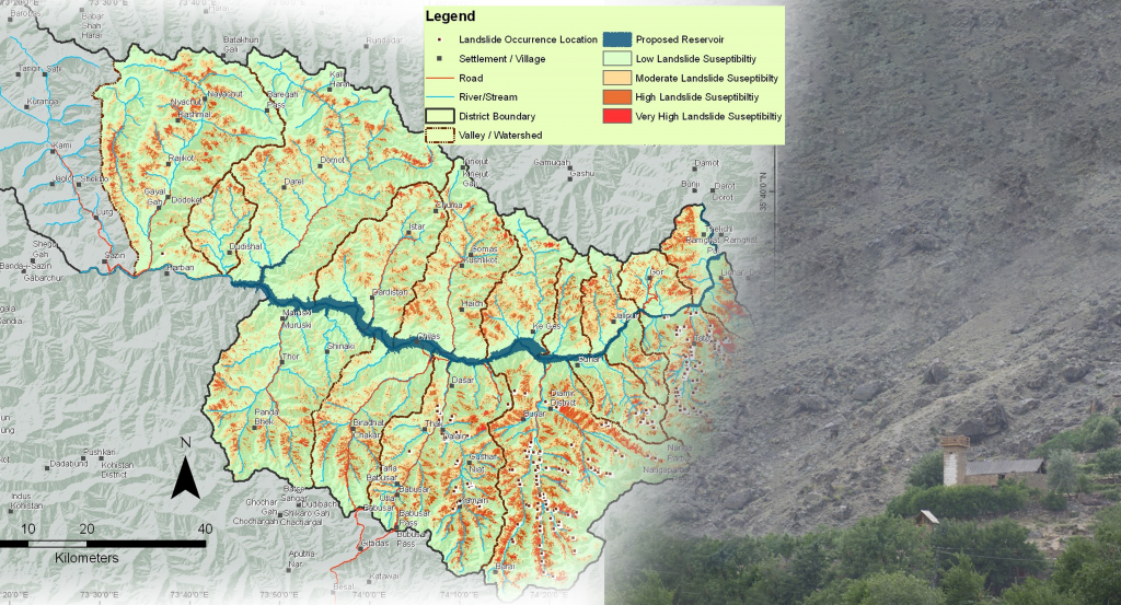
This project catered to the monitoring and evaluation requirements of land acquisition and resettlement activities in the Basher Diamer Dam Project area, comprised of the Diamer district of Gilgit-Baltistan province with 37,419 acres of land encompassing 35 villages. Two statistical approaches, Maximum Entropy and Weighted Logistic Regression, were used to calculate the probability of landslide occurrences. The ultimate goal of both approaches was to find the best-fitting model that describes the relationship between the dependent variable (landslides inventory) and the independent variables (elevation, slope, aspect, rigid terrain, distance to drainage, distance to steep drainage, geology, land use/landcover). Landslide susceptibility maps were produced using qualitative and quantitative approaches and categorized into different susceptibility classes. The geology map scale was found inappropriate to use with other variables and later dropped from the analysis. Without a geological layer, the land use/landcover (LULC) layer shows the highest contribution to landslide susceptibility. A detailed land use/landcover map of the study area was prepared from ALOS/AVNIR-2 multi-spectral data by applying object-based image classification (OBIA) techniques. The FAO and UNEP’s standard Land Cover Classification System (LCCS) was used to define classification legend systematically in the Diamer district. Among fifteen LULC classes, the bare soil and shrubs classes showed the highest contributions in determining the landslide susceptibilities.