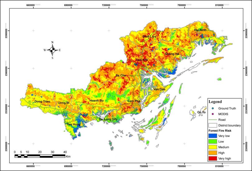
Forest Fire Risk Zone Mapping by using Remote Sensing and GIS
Year: 2007-2008
Country: Vietnam
Location within country: Quang Ninh province
The objectives of this project were: 1) To investigate the forest fire occurrence in the study area using Remote Sensing data and ground truth information, 2) To compare the hotspot from ground truth survey and MODIS Fire Product (MOD-14) for validation, 3) To generate forest fire risk zone map.
Descriptions
The study area of this project was Quang Ninh province of Vietnam. A probabilistic approach called Weighted Overlay Analysis (WOA) was used to achieve a forest fire risk zone map in this study area. This method requires identification of the causal factors of risk such as vegetation type, settlement areas, road network, slope and aspect. ALOS/AVNIR-2 and ALOS/PRISM data were not available for the whole study area, therefore the generation of DEM and vegetation map was done by using SRTM DEM 90m resolution and forest map 2005 (1:1,000,000 scale) respectively. Settlement areas and road networks were used to generate buffer zones to define their effect on forest fire with respect to the distance. Hotspots were obtained from MOD-14 product generated at AIT using data received from MODIS receiving station. Field work was carried out collecting ground truth data to validate the result. The results show that there are 8 hotspots (from the total 13 hotspots using for validation) were found to be very high risk zone, 3 points were found to be high risk zone and 2 points were found to be medium risk zone. The statistical analysis of the output shows that the area with very high risk is approximately 8.69%, high risk 39.99%, medium risk 37.41%, low risk 13.06%, very low risk and no risk is approximately 0.85% of the total area of the study site.

