Applications of RS for Topographical Mapping
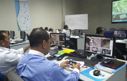
The 3-days customized professional development training program was organized in Colombo for the licensed surveyors with the close coordination of Surveyor Association of Malaysia (PEJUTA).
Microwave Remote Sensing is also called as synthetic aperture radar (SAR) which is digital signal processing lead to very flexible systems useful for military and civilian applications.
Radar has proved to be valuable before, because of its day-and-night capability and the possibility to penetrate clouds and rain. Optical instruments however had great advantages in the interpretation of depicted objects. The great wavelength of radar signals limits the achievable resolution in cross range direction of real aperture radar systems. Thus, imaging cannot be realized using static radar systems. The idea of SAR was to transmit pulses and store the scene echoes along a synthetic aperture (i.e. the path of the SAR sensor) and to combine the echoes afterwards by the application of an appropriate focusing algorithm. The combination is carried out coherently.
There were 23 senior licensed surveyors attended this training program which was conducted in Colombo, Sri Lanka upon their request. This is the sixth training program GIC has conducted for PEJUTA in last 4 years and we are very happy to note that the training program was very successful and achieved the desired objectives of imparting the SAR theory and application to the participants.

