Study on Temporal Change in Nha Trang Bay Area and the Surrounding using Satellite Data
Descriptions
The objectives of this project were: 1) To detect the landcover change including the land and water parts of the study area, 2) To detect the changes in water turbidity and its relationship to the total suspended solids.
The study area, Nha Trang is a coastal city and the capital city of Khanh Hoa province in Vietnam. Landsat-TM image of 1989 and ALOS/AVNIR-2 of 2008 were selected for multi-temporal environmental change detection of the study area, especially in the land area. The images were masked out on the land and sea parts and analyzed for the changes taken place. In the land part, the classification and analysis of the landcover change were carried out.
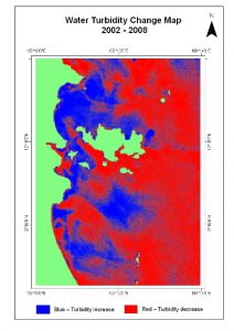
For the sea parts, analysis was done to examine the water turbidity of different levels depending on the pixel values. In order to compare the water turbidity change over years, the blue bands of Landsat ETM+ and ALOS/AVNIR-2 images were used as they are sensitive to water turbidity. Water turbidity of 2002 and 2008 were compared and the water turbidity was later converted to total suspended solids (TSS) by applying in-situ turbidity data. Results show that from 1989 to 2008 the urban area had increased from 7 km2 to 23 km2, while the vegetative area had reduced from 120 km2 to 99 km2. This shows a three-fold increase in urban area during the period from 1989 to 2008. For the sea area, from the TSS maps produced, the change in TSS is not clearly evident to come to any conclusions.

