
Area : Vietnam
Client : JAXA
Start Year : Apr 2015
End Year : Mar 2016
Partners : STI, DMC

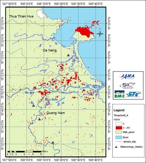
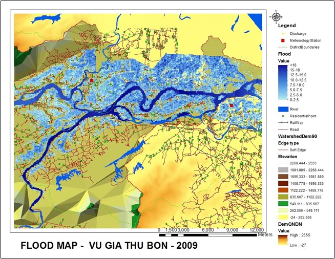


Flood Hazard Modelling and Mapping in Vu Gia Thu Bon Basin, Vietnam
The objectives of this project were: 1) To prepare flood hazard maps in the Vu Gia Thu Bon River basin using IFAS and HECRAS modeling, and 2) To generate flood inundation maps using ALOS data for a quick disaster response.
Vietnam lies in a tropical region, and its climate suffers significantly from the Asian monsoon system, mainly the northeast and southeast monsoons. Every year, Vietnam suffers from 6-10 storms and tropical depressions that cause heavy rain and floods. Storms and tropical depressions often occur from June to November, mainly in September and October. They often occur in central and northern parts of Vietnam but sometimes in the southern part. Because the central region has a sloping topography, floods in that region are flash floods that often are severe and occur throughout the year. Each year, the region is subjected to a huge loss of human life and property that requires much time and effort to overcome. The study area was in the Vu Gia Thu Bon River basin, located in the central region of Vietnam. The area of the river basin is about 10,350 sq.km. The annual rainfall in the upper part of the basin is approximately 3000-4000 mm, while the annual rainfall in the coastal areas is approximately 2000 mm. Major flood events occurred in 1964, 1999, 2007, and 2009.
For this study, IFAS was set up in two sub-basins in the upper part of the river basin, using a 1 km DEM, global land cover, soil map, and rainfall data. The observed discharge data was used to calibrate and validate the model. The model was simulated using a 3-tank layer configuration from August to November 2009 (the calibration period). The Nash Sutcliffe efficiency (NSE) model performance and the coefficient of determination (R2) were used to calibrate and validate the model at Nong Son and Thanh My stations. The NSE and R2 of the calibrated model are more than 0.6 and 0.7, respectively. Meanwhile, the validated model had the NSE and R2 values of more than 0.7 and 0.8, respectively. After the calibration and validation of the IFAS model, flood mapping was prepared using a one-dimensional flood model, HEC-RAS. The discharge from IFAS was fed into HEC-RAS for the lower part of the river basin, where flooding occurs frequently.
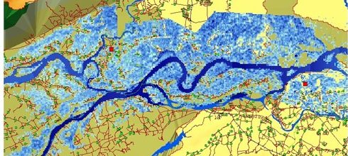
Meanwhile, ALOS/PALSAR data were processed using the NEST and ArcGIS software programs. Flood inundation maps have been prepared based on the processed pre- and post-flood images. A flood disaster that happened in the study area in 2008 was selected based on the availability of the ALOS/PALSAR data.