

Area : Kyrgyzstan
Client : JAXA
Start Year : April 2011
End Year : March 2012
Partners : –

Studying the Outburst of the Mertsbaher Lake of Kyrgyzstan using Satellite Images and Field Data
The objectives of this project were 1) To monitor the Mertsbaher lake development, 2) To find a relationship between temperature and the lake outburst, and 3) To estimate the glacier movements and velocity.
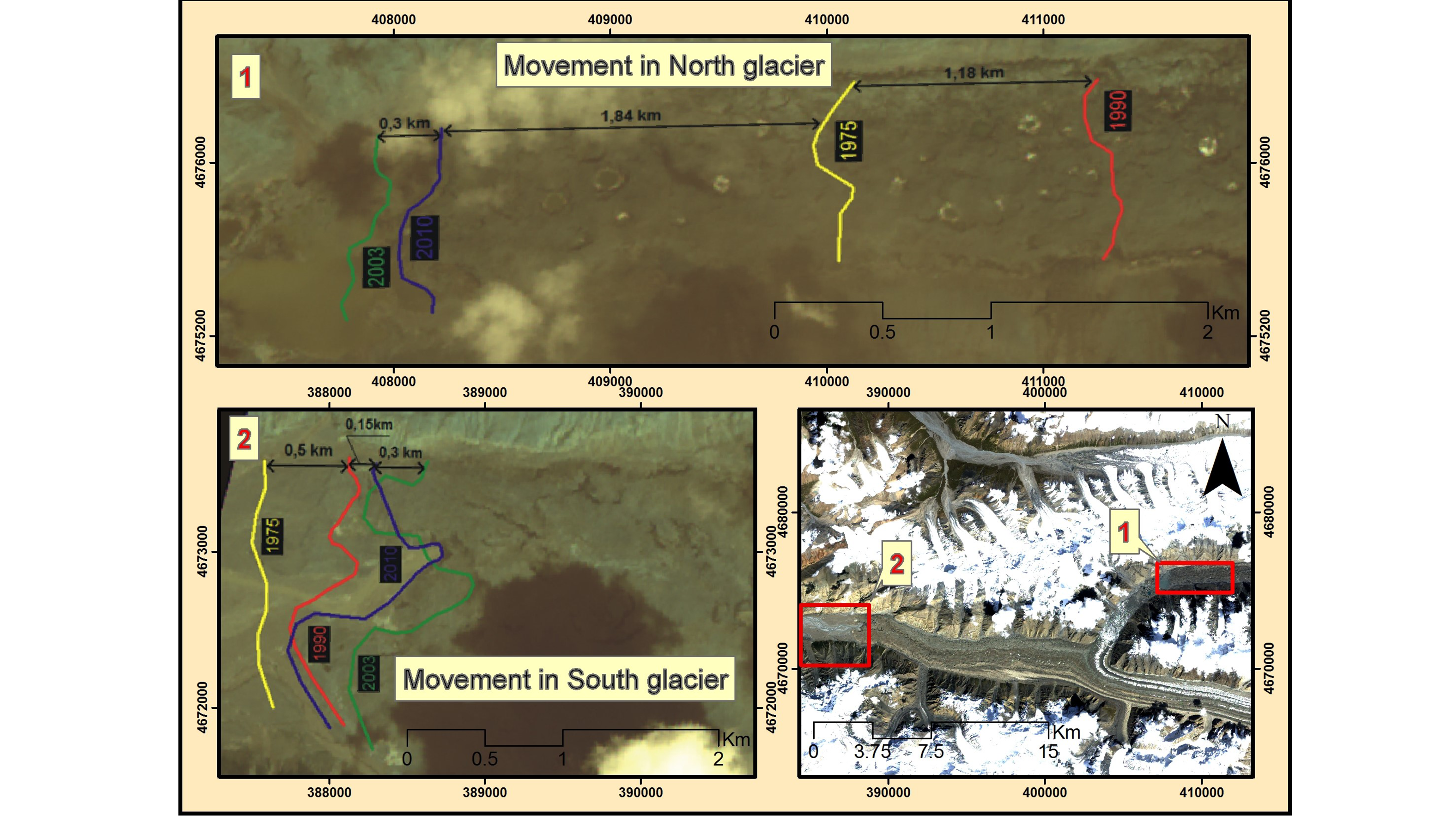
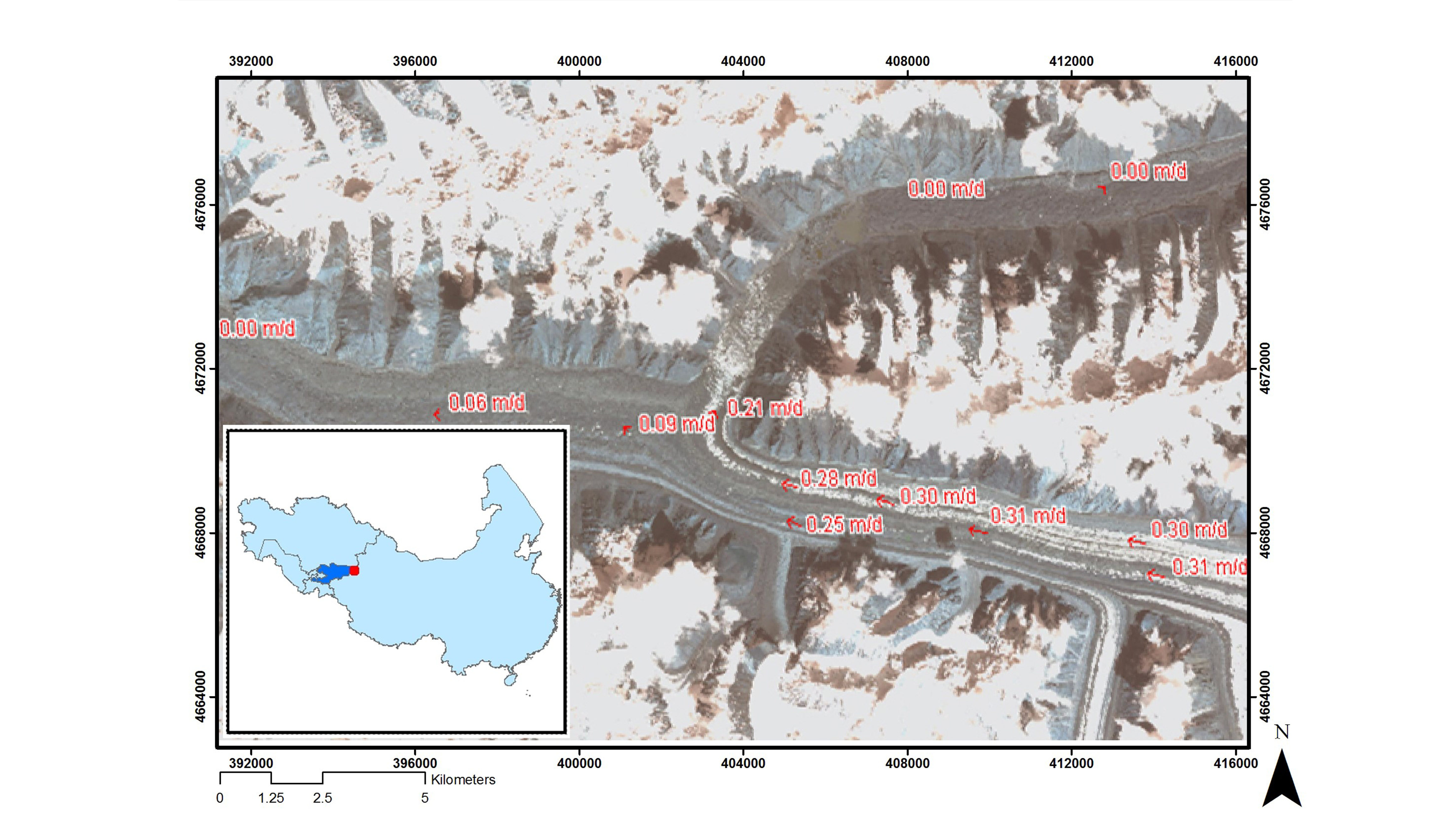
The Merzbacher Lake in the Inylchek Glacier bursts out with a flow up to 1000 m3/second due to ice movement during the summer and autumn periods and formations of cracks in a zone of unloading of the Southern Inylchek Glacier. MODIS 8-day composite from 2000 to 2011 was used to get the lakes’ surface temperature and plotted against the outburst events. When compared with the field data, the MODIS temperature showed a good correlation. It was found that the lake outburst occurs when a temperature rises a little above 10 degrees Celsius, and the frequency of the outburst is higher if it is near 15 degrees Celsius. For the monitoring of the lakes, images from 1943 to 2011 were used, including aerial photographs and satellite images such as ALOS/AVNIR-2. All the images were first geo-coded using the topographic maps of the glacier. Band combination methods were applied to these images before digitizing the lake area for a clear boundary detection of the lakes from their surroundings. It was found that there was an increase of about 0.45 km2 of surface area of the upper lake from 1975 to 2010. ALOS/PRISM image of 2006 and bathymetry map were used to generate the DEM of the lake area when the lake was empty after an outburst. The volume of water in the lake was estimated from the DEM using a truncated paraboloid equation, and an area-volume curve was generated. It was found that the critical areas for the lower and upper lakes before an outburst were 3.0 km2 and 3.58 km2, respectively, whereas the critical water volumes were 0.06 km3 and 0.07 km3, respectively. ALOS/PALSAR images were used to identify the lakes after an outburst and the regeneration process thereafter. Landsat and ALOS/AVNIR-2 images from 1975 to 2010 were used to estimate the glacier movement and velocity.
The results revealed that the Southern Inylchek glacier tongue is relatively stable. The movement of this tongue from 1975 to 2010 was 1 km. On the other hand, the Northern glacier tongue retreated about 1.18 km from 1975 to 1990 with 80 m/year, and from 1990 to 2003, the tongue advanced about 3.32 km with 250 m/year. It further showed that the North tongue was active till 2003, but now it is quite stable. The calculation of the velocity showed that the highest velocity for the period of 2006-2010 was observed in the upper part of the Southern Inylchek glacier, which was about 0.30 m/day. Near the turn of the glacier, the velocity was less (0.02 m/day). After the turn, the velocity reduced to 0.09 m/day. It conformed with the results obtained by other literature.