Biomass Estimation using SAR Data in Forest Reserve of Myanmar
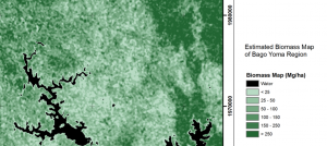
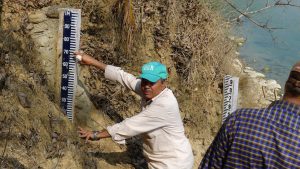
Area : MyanmarClient : JAXAStart Year : Apr 2015End Year : Mar 2016Partners : – Biomass Estimation using SAR Data in Nancho Reserve Forest and Bago Yoma Read More

Asian Institute of Technology
Area : MyanmarClient : JAXAStart Year : Apr 2015End Year : Mar 2016Partners : – Biomass Estimation using SAR Data in Nancho Reserve Forest and Bago Yoma Read More
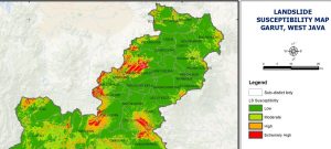
Area : IndonesiaClient : JAXAStart Year : Apr 2015End Year : Mar 2016Partners : LAPAN, BNPB Landslide Susceptibility Modelling and Mapping in Banjarnegara and Garut Districts, Indonesia Read More
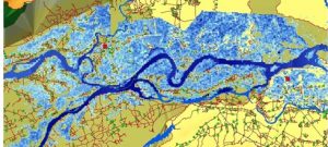
Area : VietnamClient : JAXAStart Year : Apr 2015End Year : Mar 2016Partners : STI, DMC Flood Hazard Modelling and Mapping in Vu Gia Thu Bon Basin, Read More
Area : Sri LankaClient : JAXAStart Year : Apr 2015End Year : Mar 2016Partners : SD, NBRO Landslide Susceptibility Modelling and Mapping in Badulla District, Sri Lanka Read More
Area : NepalClient : JAXAStart Year : Apr 2015End Year : Mar 2016Partners : DHM, DWIDP Flood Hazard Modelling and Mapping in West Rapti River Basin, Nepal Read More